We're up early for breakfast at the Hótel Framtíð which is located in the small fishing village of Djúpivogur. The rainy October weather has finally caught up with us.
But the forecast looks good after today.
We drive around the peninsula and see some of the salmon fish pens.
We're also treated to a couple of seals, who look just as interested in us as we are of them.
John Paul, our Nordic Visitor guide, tells us we are in the oldest part of Iceland. Rocks have been dated to 18 million years ago.
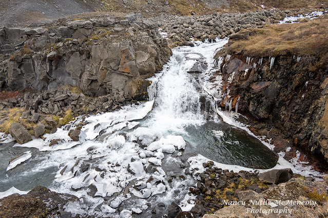
Our first stop is at Nykurhylsfoss that is also called Sveinsstekksfoss or even Fossárdafoss. It's a hidden waterfall on the Fossá river in the area of Fossárdalur in the eastern part of Iceland outside of Djúpivogur.
Local legends say that there is a petrified troll woman here at the falls. Can you find her?
Up the road we stop for some sheep photo ops.
After some time with the "locals"...we head to Fáskrúðsfjörður, located on the same-named fjord. The village lies between Reyðarfjörður and Stöðvarfjörður and is one of the easternmost settlements of Iceland.
Fáskrúðsfjörður was home to a hospital founded to serve French fishermen working here until 1935. The former hospital building dating from 1903 has now been restored as a hotel.
Even nowadays there are bilingual signs in town indicating the street names in Icelandic and in French. The French cemetery with 49 graves of fishermen from France and Belgium is another tourist attraction. The cross was erected in 2009.
The village is now a center for visitors viewing the Northern Lights.
A local guide, gives us a little tour of the Aurora building and the village and invites into the local co-operative craft gallery for tea with smoked lamb and butter on crackers, cheese and butter in crackers, licorice candy, cake and time for some shopping.
I found a lovely hat (on sale) and found out later in the day that it keep me super warm-SCORE!!
Back in the van we travel through a VERY LONG tunnel and start to drive away from the coast, we're heading up into the mountains. It's foggy, icy and a little snowy.
The folks traveling with us from warmer climates (Florida; Melbourne, Australia and Bombay, India) ask for a photo op stop.
Wait 'til they tell the folks back home about how they played in Icelandic snow!
We are in the town of Egilsstaðir, it has a subarctic climate or a subpolar oceanic climate bordering very closely on a Tundra climate. Winters here tend to be colder than other towns in the area.
There is even an airport serving this part of the country.
Along the highway we see another waterfall. Rjúkandi, also known as Rjúkandafoss, is the twelfth tallest waterfall in Iceland.
Rjúkandi contains multiple drops, but collectively it reaches 305 ft (93 m). Its impressive height makes it hard to miss, and it’s also one of the few significant waterfalls that can be seen directly off the northern portion of the Ring Road (Route 1).
After some more icy, windy, white-out driving, we've entered a snow-covered dessert area. We're about 2000 ft now and very near Lake Mývatn.
From Wiki: "Krafla is a volcanic caldera of about 10 km in diameter with a 90 km long fissure zone. It is located in the north of Iceland in the Mývatn region and is situated on the Iceland hotspot atop the Mid-Atlantic Ridge, which forms the divergent boundary between the North American Plate and the Eurasian Plate. Its highest peak reaches up to 818 m and it is 2 km in depth. There have been 29 reported eruptions in recorded history."
There's actually a place to stop for pastries and coffee in this cold and empty place. A local farmer runs this café and I just have to try the "love balls" Astrapungar. They we like doughnut hole but bigger. YUM!
It's quite an eerie place...
After our coffee break we head to Námafjall or Hverir.
Námafjall is a geothermal area located east of Lake Mývatn, looking like a mixture of an alien landscape and the Hell from Dante’s Inferno.
This site features a large collection of boiling mud pots and steam springs called fumaroles, which are openings in the ground that emit sulfurous gases. And lots of mud-my hiking boots still have mud on them.
Hrossaborg, a 10,000-year-old crater formed when rising magma heated groundwater, prompting a massive explosion of steam and rock. Hrossaborg was once used as a pen for rounding up horses -- thus the name, which means "Horse Castle."
It's getting dark. I hope I can get better photos of this crater tomorrow in the day light.
This crater was featured in the Tom Cruise movie "Oblivion" and was used to train the Apollo astronauts.
Here's a little featurette from the Cruise crew.
While the others are bathing, the rest of us head to Lake Mývatn to walk around the lake.
It's really getting dark now.
We pick up the bathers and head to our hotel.
We are staying at the Hotel Laxá. It's in the middle of nowhere and should be great for Northern Lights, EXCEPT it's still too cloudy. But dinner was delicious.